Orlando residents know that hurricane season is a time to keep a watchful eye on the tropics, and this year is no exception. With a new tropical wave now rolling off the coast of Africa and gathering steam, Central Florida’s attention is once again turning eastward. Experts warn that this system has a higher chance of becoming our next named storm, and while it’s still far out at sea, early models suggest it could take a path that brings it uncomfortably close to the Sunshine State. Here’s what Orlando locals need to know about this developing weather situation, and why it’s so important to stay alert as the Atlantic heats up.
The Tropics Are Heating Up: What’s Happening Now?
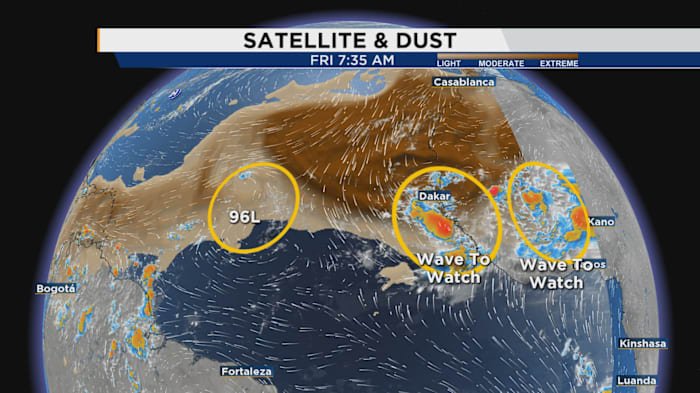
Every summer and fall, the Atlantic hurricane basin comes alive, but not all tropical waves are created equal. The latest system to roll off Africa’s west coast is showing signs that it could organize quickly. The National Hurricane Center (NHC) has already flagged this wave as having a higher-than-average likelihood of development over the next week.
Why does this matter for Orlando? While many tropical systems curve harmlessly out to sea, some track straight across the Atlantic, putting Florida—and especially Central Florida—on alert. With waters near the Cape Verde islands warmer than usual and wind conditions favorable for storm growth, meteorologists are keeping a close eye on this one.
How Orlando Could Be Impacted
Even if the storm never makes a direct landfall in Orlando, our city can still feel its effects. Central Florida is no stranger to heavy rainfall, gusty winds, and the occasional tornado spawned by passing tropical systems. Orlando’s location inland gives us some protection from the fiercest hurricane winds, but flooding and power outages remain real concerns.
Last year, Hurricane Ian’s path through Central Florida brought days of disruption, with flooding in neighborhoods and canceled events across Orlando. The new tropical wave, if it develops into a named storm and tracks toward Florida, could bring similar challenges. Now is the time for Orlando residents to review their preparedness plans, check their emergency supplies, and stay tuned to local updates from trusted sources like Daily Orlando News.
What the Forecast Models Say
Forecasting the path of a tropical system this far out is always tricky. Computer models run dozens of possible scenarios, and the “spaghetti plots” that result can look like a tangled mess. Still, when forecasters see a cluster of models suggesting a potential westward track, it’s a signal to pay closer attention.
As of now, the latest runs from the European and American models show a few possible tracks for this wave—some curving north and missing the U.S. entirely, others showing a more westerly path that could bring the storm closer to Florida’s east coast. Even if the storm stays offshore, Orlando could see indirect impacts: increased rain, higher humidity, and the possibility of severe thunderstorms as the system passes by.
Remember, these forecasts can change rapidly as new data comes in. That’s why meteorologists urge Orlando residents to check reliable sources frequently and avoid spreading rumors or unverified social media posts about the storm’s path.
Preparedness Tips for Orlando Residents
While it’s too early to say whether this tropical wave will become a named storm or threaten Central Florida directly, now is the perfect time to get ready. Here are some steps Orlando locals can take:
- Review your hurricane kit: Make sure you have enough water, non-perishable food, flashlights, batteries, and medications to last at least three days.
- Check your home: Clear gutters, trim tree branches, and make sure your windows and doors are secure.
- Stay informed: Sign up for emergency alerts from the City of Orlando and Orange County. Follow trusted local news sources like Daily Orlando News for the latest updates.
- Know your flood zone: Even areas that rarely flood can be at risk during heavy tropical rains. Check city resources to find your flood zone and plan your evacuation route if needed.
Having a plan in place before a storm threatens makes it easier to stay calm and act quickly if the forecast changes.
Staying Weather-Wise All Season Long
Orlando isn’t on the coast, but we’re close enough that every new tropical system deserves our attention. With climate patterns evolving and Atlantic waters running warmer, experts say this could be a busy hurricane season. The key for Central Floridians is awareness, preparation, and staying connected to trustworthy information.
The coming days will bring more updates as meteorologists track the tropical wave’s progress across the Atlantic. Whether or not it becomes a threat to Orlando, paying attention now puts you ahead of the curve—and ready for whatever Mother Nature brings.
Conclusion: Stay Alert, Stay Prepared
As we track the latest tropical wave and its possible development into a named storm, the message for Orlando is clear: stay vigilant, stay prepared, and stay informed. The tropics can change quickly, but with the right information and a solid plan, Central Floridians can weather whatever comes our way.
How are you preparing for hurricane season in