Orlando residents are no strangers to hurricane season anxiety. Each year from June through November, eyes turn anxiously to the tropics, tracking every swirl that could impact Central Florida. Yet, as we approach the midpoint of summer 2024, something unusual is unfolding: the Pacific Ocean is buzzing with storm activity, while the Atlantic basin, including the Gulf of Mexico and the Caribbean, remains stunningly quiet. Is this a rare meteorological fluke, or is there a reason behind the calm? And what does it mean for Orlando and the rest of the Sunshine State?
Unusual Calm in the Atlantic: How Rare Is It?
Historically, by July, the Atlantic hurricane season has typically produced at least a couple of named storms. However, as of now, there is nothing brewing across the Atlantic basin. The National Hurricane Center’s outlooks remain largely uneventful, with no tropical development expected for the next week or more. For Orlando residents still recovering from previous hurricane seasons, this calm brings a sigh of relief—but also a sense of unease. Is this quiet spell normal, or should we be bracing for a delayed but active season?
According to meteorologists, lulls like these, while not common, are not entirely unheard of. Some hurricane seasons start slow and ramp up quickly in August and September, which are the historical peaks. Still, the lack of early activity is a notable departure from recent years, which have seen early-season named storms become almost routine.
Pacific Storms Surge: What’s Fueling the Activity?
While the Atlantic takes a breather, the Pacific Ocean is telling a completely different story. Multiple tropical storms and even hurricanes have spun up in recent weeks, grabbing headlines and impacting communities from Mexico to Hawaii.
The culprit? Meteorologists point to a combination of warmer-than-average Pacific sea surface temperatures and the lingering effects of El Niño—a climate pattern known for shifting weather systems globally. These conditions are ripe for storm development in the Pacific, while, paradoxically, they often act to suppress hurricane formation in the Atlantic.
Why Does This Happen? The Science Behind the Split
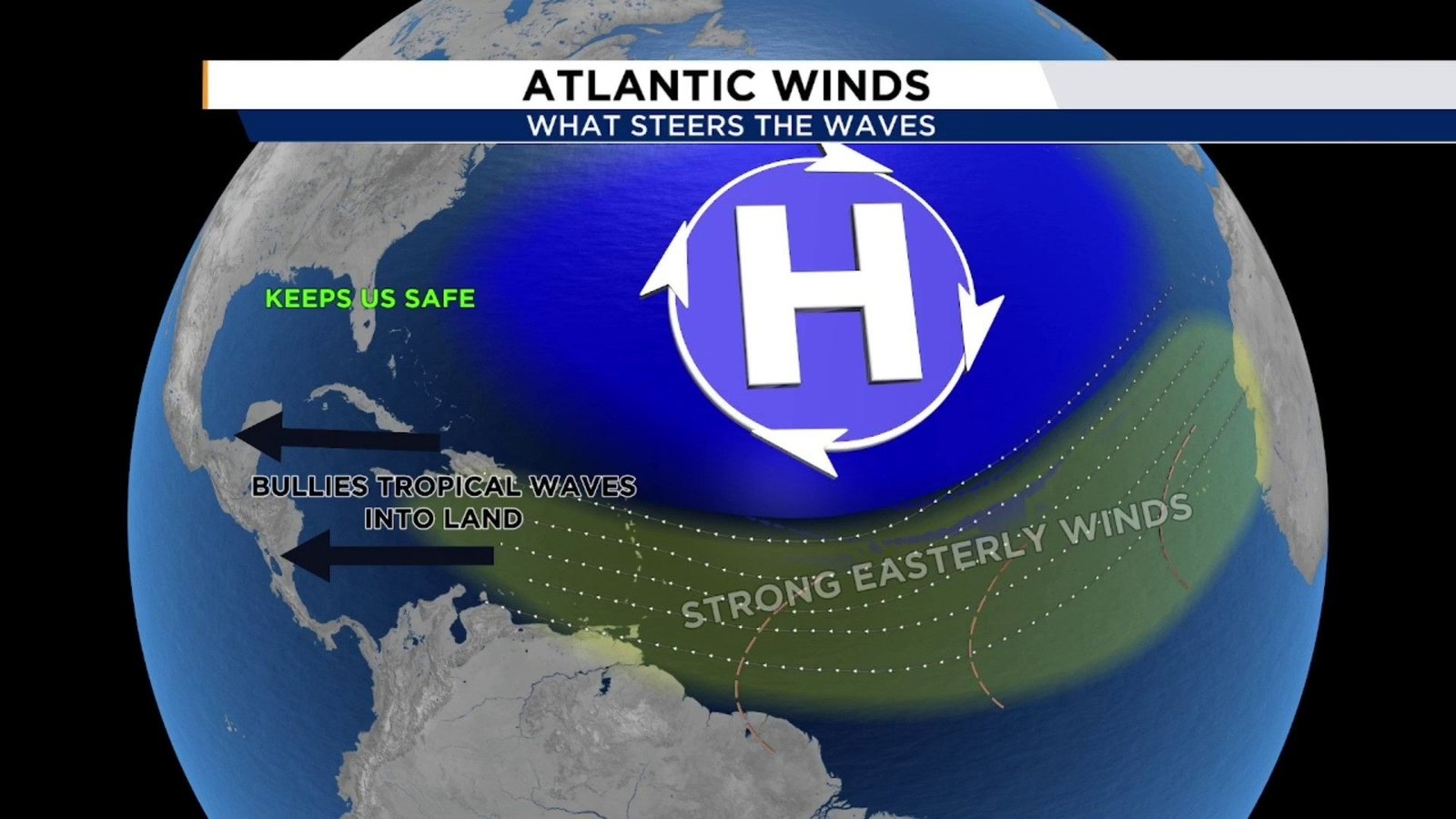
The answer lies in the complex dance of global weather patterns. El Niño, which is currently present, tends to enhance wind shear over the Atlantic. Wind shear is the difference in wind speed and direction at different altitudes. Too much wind shear tears apart developing storms before they can organize, leading to quieter periods in the Atlantic basin. Meanwhile, El Niño often reduces wind shear in the Eastern Pacific, contributing to a more active storm season there.
For Orlando and the rest of Florida, this means a temporary respite from the threat of hurricanes. However, it’s important to remember that the situation can change quickly—especially as El Niño weakens or fades, potentially allowing the Atlantic to “catch up” later in the season.
What Does This Mean for Orlando and Central Florida?
For now, the quiet Atlantic offers a welcome break. With no immediate threats on the horizon, Orlando residents can focus on summer fun instead of storm prep. However, local experts caution against complacency.
- Peak hurricane season is still ahead: The majority of Florida’s hurricanes occur in August, September, and early October. The quiet start doesn’t guarantee a quiet finish.
- Stay prepared: Now is the ideal time to review your storm supplies, check evacuation routes, and make sure your insurance is up to date.
- Weather patterns can shift fast: Meteorologists warn that just a few weeks of favorable conditions—like warmer Atlantic waters or reduced wind shear—could spark a flurry of storms late in the season.
Orlando’s position inland offers some protection from direct hurricane strikes, but as recent years have shown, even weakening storms can bring heavy rain, flooding, and power outages to Central Florida.
Looking Forward: Should We Expect a Busy Season?
The official hurricane season runs through November, and many forecasters still anticipate an above-average number of storms, thanks to record-warm Atlantic waters. El Niño is expected to weaken as the summer progresses, which could open the door for more active weather later on.
For now, this unusual split—an active Pacific and a dormant Atlantic—reminds us that every hurricane season is different. Weather models can improve, but nature always has surprises in store.
Conclusion: Orlando, Stay Alert and Prepared
While the Atlantic remains calm for the time being, Orlando should not let its guard down. The tropics can change on a dime, and history shows that even quiet starts can end with dangerous storms. Use this rare lull as an opportunity to get your hurricane kits in order, review your safety plans, and stay connected with Daily Orlando News for the latest updates.
What do you think about this unusual hurricane season so far? Are you relieved, worried, or just cautiously optimistic? Leave a comment below and share your thoughts or preparations with your fellow Orlando neighbors!