Orlando, FL — As summer storms begin to brew over the Atlantic, the National Hurricane Center (NHC) has flagged a new system, Invest 95L, just off the coast of North Carolina. While this particular disturbance is not expected to threaten Florida, its arrival marks the likely start of a busier hurricane phase for the Atlantic region. For Orlando residents, staying informed about these developments is crucial as our city continues to prepare for whatever this season may hold. Here’s what you need to know about Invest 95L, what its formation means for Central Florida, and how to stay ready as the Atlantic hurricane season ramps up.
What Is Invest 95L?
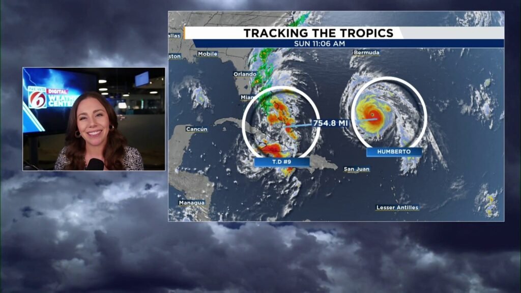
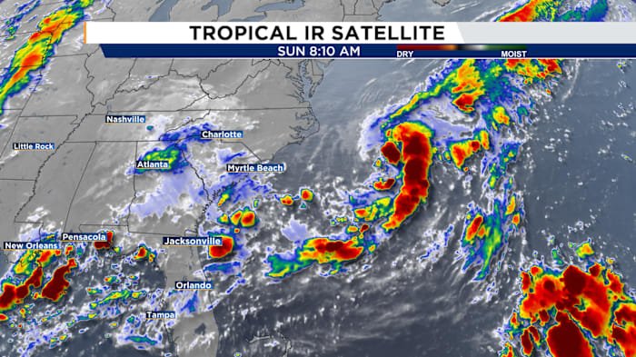
Invest 95L is a term used by the NHC to identify and monitor an area of disturbed weather that has the potential to develop into a tropical cyclone. This system formed off the coast of North Carolina and is currently moving away from the southeastern United States. Satellite imagery and meteorological data show that while Invest 95L is organizing, environmental conditions are only marginally favorable for further development. The NHC is tracking its progress closely, but at this time, the system poses no threat to the Florida peninsula, including Orlando.
Designating an area as an Invest allows meteorologists to dedicate specialized resources and models to monitor the system. This helps experts better predict its path and potential for intensification, which is crucial for early warning and preparedness efforts up and down the Atlantic coast.
Why Invest 95L Matters for Orlando
Although Invest 95L is not projected to impact Central Florida directly, its early appearance serves as an important reminder for Orlando residents: hurricane season is entering a potentially active phase. In recent years, Orlando has experienced the effects of hurricanes and tropical storms, mainly through heavy rains, strong winds, and occasional tornadoes. Even storms that don’t make landfall in Florida can bring increased rainfall and gusty conditions to the region.
This is the time for locals to review hurricane preparedness plans, check emergency kits, and stay tuned to trusted local news outlets like Daily Orlando News for updates. The beginning of increased Atlantic activity means it’s not too soon to take precautionary measures, especially with the memory of last year’s active season still fresh in our minds.
What Experts Are Saying About the 2024 Hurricane Season
Meteorologists and climate experts have been forecasting an above-average hurricane season for 2024. Warmer-than-normal Atlantic sea surface temperatures and the fading influence of El Niño are creating conditions ripe for more frequent and intense storms. The formation of Invest 95L in early June supports these predictions and signals that tropical activity may ramp up earlier than usual.
Dr. Lisa Rodriguez, a hurricane specialist at the University of Central Florida, commented, “The early designation of systems like Invest 95L is a clear indicator that we need to be vigilant this season. Orlando might not be in the direct path of every storm, but being prepared is key for minimizing risk and disruption.”
The NHC will continue to monitor the Atlantic closely. Residents are urged to sign up for emergency alerts and have a reliable source of weather information as the season progresses.
How to Prepare in Orlando: Key Hurricane Tips
- Review Your Emergency Plan: Make sure your family knows what to do if a storm threatens. Designate a safe room and a meeting place if you get separated.
- Stock Up on Supplies: Keep at least three days’ worth of non-perishable food, water, medication, batteries, and pet supplies on hand.
- Stay Informed: Follow updates from the National Hurricane Center and local news sources for the latest forecasts and advisories.
- Protect Your Home: Inspect and repair roofs, windows, and doors. Trim trees and secure outdoor items to reduce the risk of wind damage.
- Know Your Flood Risk: Orlando may not be coastal, but heavy rainfall from tropical systems can cause localized flooding. Check if your home is in a flood-prone area and consider flood insurance.
Many Orlando residents recall how even distant systems can bring torrential downpours and power outages. Taking steps now can save stress and resources later in the season.
Looking Ahead: Monitoring and Community Resilience
With the Atlantic hurricane season just starting to heat up, the formation of Invest 95L is a wake-up call for Orlando and surrounding communities. While this system isn’t a threat to Florida, it’s a signal to stay alert and prepared. Local officials and emergency management teams are already ramping up readiness efforts, ensuring resources and shelters are in place should a storm approach.
Community resilience is built on preparation and communication. By staying informed through local news, official weather alerts, and community forums, Orlando residents can weather the season safely and confidently.
Conclusion
While Invest 95L is unlikely to affect Orlando directly, it marks the beginning of what could be a busy and challenging Atlantic hurricane season. Now is the perfect time to double-check your emergency plan and supplies, stay tuned to Daily Orlando News for regular updates,