The Atlantic hurricane season is heating up, and this weekend could bring our next named storm: Fernand. The National Hurricane Center (NHC) has designated a new area of interest—Invest 90L—raising the likelihood that this system could strengthen and earn a name as early as this weekend. With the Orlando area always keeping a wary eye on developing tropical weather, locals are wondering: What’s the latest on Invest 90L, and what does it mean for Central Florida? Here’s everything you need to know, from how to pronounce Fernand to how to prepare for potential impacts.
Invest 90L: What Is It and Why Does It Matter?
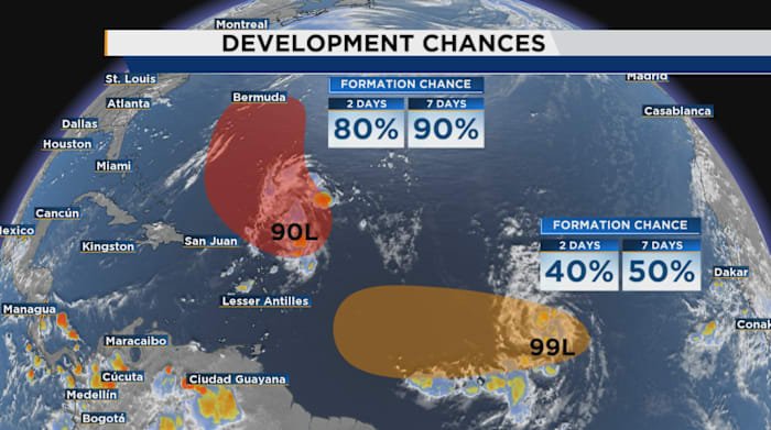
On Thursday afternoon, meteorologists at the NHC officially tagged a disturbance in the Atlantic as Invest 90L. That designation means the system is being closely watched for possible development into a tropical depression or storm. The “Invest” label allows forecasters to run specialized computer models, collect data, and issue updates for public awareness.
Invest 90L currently sits a few hundred miles east of the Lesser Antilles, churning in warm waters with favorable atmospheric conditions for strengthening. While it’s too early to predict its exact path, computer models suggest that this system has a good chance of developing into a named storm—possibly as soon as this weekend.
For Orlando residents, it’s important to note that even if 90L doesn’t come directly our way, these systems can bring heavy rain, gusty winds, and increased tornado risk to Central Florida. Staying informed now helps us stay safe later.
Next Up: Fernand—How Do You Pronounce It?
Once Invest 90L reaches tropical storm strength, it will be named “Fernand,” the next name on the 2024 Atlantic hurricane list. Pronounced Fair-NAHN (emphasis on the second syllable), the name has already sparked online chatter—many are surprised by its French-inspired pronunciation.
The NHC provides pronunciation guides for all storm names, which is helpful for news anchors and meteorologists, but also for everyday Floridians who want to stay in the know. So if you hear talk of Fernand on local Orlando news or social media, remember: it’s not “FUR-nand” or “FERN-and,” but “Fair-NAHN.”
Potential Impacts: What Could Fernand Mean for Orlando?
Though it’s still early in the forecast, Orlando-area residents should closely monitor updates on Invest 90L as the system develops. Here’s what we could expect if Fernand heads our way or brings indirect impacts to Central Florida:
- Heavy Rainfall: Even a glancing blow from a tropical storm can bring several inches of rain, leading to localized flooding. Orlando’s low-lying neighborhoods and busy roadways are especially vulnerable after heavy downpours.
- Gusty Winds: While hurricanes tend to weaken as they move inland, strong tropical storms can still bring damaging wind gusts. Secure loose outdoor objects and be cautious of falling branches or debris.
- Tornado Risk: Central Florida often sees increased tornado warnings with landfalling tropical systems. Keep your weather alerts active and know your safe place.
- Travel Disruptions: Orlando International Airport and local highways can see delays or closures during severe weather. Monitor MCO’s official site for updates if you have travel plans.
It’s too soon to know exactly how much of an impact Fernand will have on Orlando, but it’s always wise to review your emergency kit and stay tuned to trusted local sources like Daily Orlando News for real-time updates.
How Orlando Residents Should Prepare
Preparedness is key, especially during hurricane season. Here are some tips for Orlando locals as we watch Invest 90L’s progress:
- Review Your Hurricane Plan: Know your evacuation route, stock up on food and water, and check your emergency supplies.
- Stay Informed: Follow the National Hurricane Center and trusted local news outlets like Daily Orlando News for the latest updates.
- Charge Devices: Power outages are common during tropical storms. Make sure your phones and battery backups are fully charged.
- Check on Neighbors: Look out for elderly or vulnerable neighbors who may need extra help preparing.
Orlando’s recent history reminds us that even weaker storms can cause big problems—especially when it comes to flooding and power loss. Don’t wait until the last minute to get ready.
What’s Next? Tracking Fernand and the Busy Season Ahead
The Atlantic hurricane season runs through November 30, but the peak is still ahead. Forecasters expect an above-average number of storms this year, so staying vigilant is crucial for everyone in Orlando and across Central Florida.
Over the coming days, all eyes will be on Invest 90L as it moves westward and potentially earns its name. Whether it’s Fern